at Onondaga Cave State Park
 |
|---|
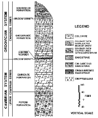
So what happened here at Onondaga Cave? About a billion years ago, the Ozarks were a hotbed of volcanic activity centered about 45 miles to the southeast, in Iron and Reynolds counties. The igneous remains of this activity formed the surface of granites, rhyolites, felsites and basalts that are exposed there. These rocks are the basement layer here, about 1,000 to 1,500 feet below the cave. This basement layer is not flat but tilted. About 600 million years ago, this volcanic activity calmed and the region cooled, condensing great amounts of water vapor, which formed shallow (about 200 foot deep) seas. These seas were the birthplace of the Eminence and Gasconade formations of dolomite, chert, sandstone and shale in which Onondaga Cave is formed. It is believed that the Ozarks were uplifted above sea level (or the seas retreated, take your pick) four times before they fell for the last time about 280 million years ago. One final major uplift (of dry land) took place 50 million to 7 million years ago. During the four times this area was underwater, there was depositing of sea sediments and the formation of sedimentary rock. Even now, the earth is not still, which is the reason for the seismic station in Cathedral Cave.
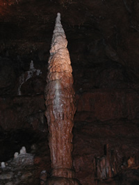
This part of the Ozarks has been dry land for so long that the rocks laid down 440 to 280 million years ago have eroded away. The level of the land has been reduced by at least several hundred feet. The surface rock is Gasconade dolomite, which contains chert gastropod fossils, and is about 490 million years old. Gasconade dolomite makes up the Onondaga Cave roof. Some of the lower parts of the cave are in Eminence dolomite, which is up to 550 million years old. Eminence dolomite does not have many visible fossils, but it does have stromatolites, which are blue-green algal reefs that have been replaced by chert (quartz, with calcium silicate). Younger rocks such as Roubidoux sandstone are sometimes found as loose pieces or "float" on the surface outside the cave. The gritty surfaces of the dolomites in the cave are dolomite sand, not quartz. Some of the speleothems on the railings are the youngest rocks of all, since they are constantly dripping and forming as you read this.
Most estimates date the actual formation of Onondaga Cave to the last few million years. The problem in dating a cave is--because the cave is what is not there--how do you measure a void? Do you start when water started trickling through a crack? Or when it got large enough to measure (though there weren't people here to do it)? Or do you date it from the time (still undetermined) when it became enterable? Even by doing isotope tests on the speleothems, you only determine the age of the speleothems, not the cave. So, beyond a few million years, we simply don't know.
 |
|---|
What is pretty obvious, though, is why Onondaga Cave formed here. In addition to adequate rainfall, plant life and the right kind of rock, "here" has another critical element: the Leasburg Fault. A fault is a crack in the rock where uplift or sideways movement has caused the rock to shear, so that the layers on either side do not line up. In this case, the block of land on the northeast side of the fault has moved upward, while that on the southwestern side has been downthrown. The difference between what would have been matching layers is 55 feet here in the park. The fault itself runs roughly down the campground valley. Cathedral Cave is on one side of the fault, and Onondaga Cave is on the other. The Leasburg is a fairly minor fault, and not particularly active.
Because of the Leasburg Fault, stresses and strains on either side fractured the rock more than usual. Water, taking the path of least resistance, entered these fractures, even while they were far under the surface, and formed the caves. Studies of the water in Onondaga Cave streams after a rain show that the cave apparently drains water from all along the fault, not just over the immediate area. The cave stream in Cathedral Cave drains an entirely different surface valley. These cave streams are not the ones that formed the caves, and are considered younger than the caves themselves, which are older than the current landscape. Even though topography changes as erosion occurs, the basic drainage patterns of an area rarely change, as they are controlled by the contours of the basement rock.
What happened to form Onondaga Cave was probably something like this: the ground surface was much higher when the cave formed. The proto-Meramec flowed at a higher level on that surface. As mechanical erosion allowed access to bedrock, chemical solution began to dissolve it. Most of the large passage in Onondaga Cave was formed then, when it was still below the water table. The shape of the cave was determined by areas of more or less resistant rock and the position of joints and fractures caused by the Leasburg Fault. The size of the cave chamber is partially the result of fractured rock, making it easier to dissolve. Periods of quiet flow account for the depositing of red clay and chert, residue from the dolomite, brought in from the surface. The land eroded and the water table dropped, letting air into the cave, along with trickles of water, which became the cave stream. These streams began to cut the red clay and chert fill, and to carve their streambeds, which became smaller passages in the cave. Because the groundwater entering the cave found air-filled passages, speleothems began to grow. Finally, the Meramec River valley cut down enough to carve through the end of the cave, creating a spring and allowing access.


