at Onondaga Cave State Park
 In his book "Caves of Missouri," J. Harlen Bretz describes Cathedral’s entrance passage: "The low entrance by which the cave was discovered many years ago is heartily detestable, and never used without some special reason."
Cathedral Cave is 15,639 feet long (2.96 miles) and was first entered by Fair and Everett Pinnell in 1919, though Lester Dill claimed to have seen the entrance five years earlier. Locals explored the cave, and the current commercial entrance was dug around 1930. In the early 1970s, workers installed concrete walkways, handrails and a fluorescent lighting system. Because Dill fully expected to lose the cave to a lake resulting from the Meramec Dam project, no particular care was taken to preserve speleothems or even clean up the construction debris. The proposed dam was defeated in a referendum in 1978, and commercial operation of the cave ceased. Sometime between when it closed and when the property was acquired as a state park in 1981 after Dill’s death, the cave was broken into and vandalized, apparently to collect scrap copper from the wiring of the lighting system. The lighting system was never rebuilt, and today’s tours are by flashlight, provided by the park. This makes for a more "wild" cave experience.

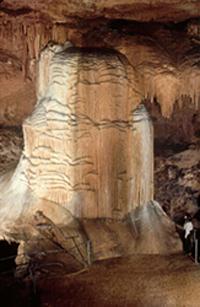
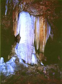
Tours of the cave begin in the upper passage, entering through a hillside on the Deer Run Trail, and end at the Cathedral Bell, a large bell-shaped wall of flowstone from which the cave gets its name. The commercial section of the cave contains plentiful speleothems, several slump pits, a natural bridge and a nearly 80-foot-high ceiling. Sights in this section include giant stromatolites – fossilized mounds of once photosynthetic algae – situated in part of an ancient exposed reef, and wind-bent soda straws and stalactites. If you look closely, you might see delicate helictites, which sprout from the ceiling and from the sides of soda straws, seemingly curling and branching at random.
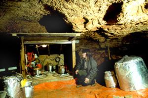
About 1,200 feet into the cave is the CCM (Cathedral Cave, Missouri) Seismic Station, an underground earthquake monitoring node operated by St. Louis University. Data picked up at this station goes through fiber optic cable to the visitor center, where it is processed and sent to the National Earthquake Center in Golden, Colorado. More information on earthquakes and the station is available from park staff, and real-time CCM seismographs can be found here.
The commercial trail ends at the 25-foot-high, 15-foot-wide and 10-foot-thick column known as the Cathedral Bell. The cave stream passage continues another 4,100 feet beyond the tour route, out to the river entrance. Most of this passage involves stooping or walking along a very wet, slightly decorated stream canyon with a few outstanding speleothems and much sharp chert and dolomite scalloping of the cave walls. Approximately 1,000 feet from the natural entrance, the passage forks and the cave stream siphons to the left. At this point, the stream disappears from the cave, goes under the Meramec River, and eventually emerges near the far bank, as evidenced by a dye tracing in 1991. The drier right-hand passage leads to the natural entrance, now guarded by a locked gate.


