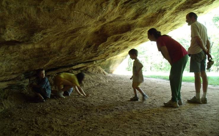
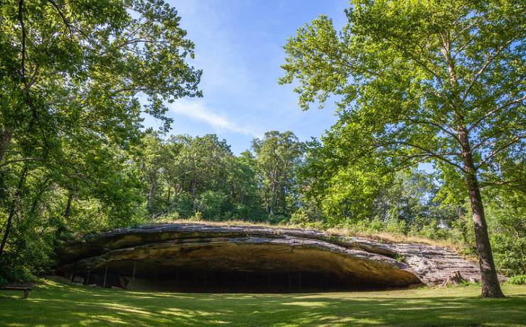
Park Map
![]() |
217 Hwy. TT,
Montgomery City, MO 63361 573-564-3476 Off I-70, take Exit 170, go left on Hwy. TT for 2 miles, Montgomery County |
Map of Graham Cave SP How to get to Graham Cave SP Places to visit nearby |
Map of Graham Cave State Park

Directions to Graham Cave State Park
From St. Charles
Graham Cave State Park is approximately 54 miles west of St. Charles. Allow one hour for the trip, depending upon traffic. Travel west on I-70 to Exit 170 (Danville/Montgomery City). Turn right, then turn immediately left onto Hwy. TT (north outer road). Continue on Hwy. TT for two miles; it ends in the state park.
From Kansas City
Graham Cave State Park is approximately 162 miles east of Kansas City. Allow three hours for the trip, depending upon traffic. Travel east on I-70 to Exit 170 (Danville/Montgomery City). Turn left, then make another immediate left onto Hwy. TT (north outer road). Continue on Hwy. TT for two miles; it ends in the state park.
From Jefferson City
Graham Cave State Park is approximately 61 miles northeast of Jefferson City. Allow 1 hour 15 minutes for the trip, depending upon traffic. Travel north on U.S. Hwy. 54 to Kingdom City. Take I-70 east to Exit 170 (Danville/Montgomery City). Turn left, then make another immediate left onto Hwy. TT (north outer road). Continue on Hwy. TT for two miles; it ends in the state park.
From Hannibal
Graham Cave State Park is approximately 110 miles southwest of Hannibal. Allow two hours for the trip, depending upon traffic. Travel south on U.S. Hwy. 61 south to Wentzville. Take I-70 west to Exit 170 (Danville/Montgomery City). Turn right, then turn immediately left onto Hwy. TT (north outer road). Continue on Hwy. TT for two miles; it ends in the state park.

Places to visit nearby
Danville Conservation Area
Area attractions, Hermann
Winston Churchhill Memorial and Library, Fulton

